The Dunington-Grubb Report - Post 14
The outbreak of the First World War led to the cessation of many city planning projects in Brantford. The development and enhancement of the road network is the one most felt by residents today. The Dunington-Grubb Report, commissioned by the Parks Commission, was prepared by H.B. and L.A. Dunington-Grubb, and delivered to the city in December-1914. It was the city’s first attempt at a comprehensive city plan outlining the probable needs of Brantford during the next fifty years. The report discusses existing conditions in the city such as the distribution of residential and industrial areas and the number of parks. The architects then list their proposals for the city regarding streets, street railways, bridges, parks, the Farmers’ Market, and housing.
Lorrie Alfreda Dunington and Howard Burlingham Grubb were landscape architects who adopted the surname Dunington-Grubb following their nuptials in England in 1911. That same year, they emigrated to Canada, established a landscape architectural practice in Toronto, and founded Sheridan Nurseries in 1913 in Sheridan, a hamlet outside of Oakville, Ontario. In 1934, they were founding members of what is now the Canadian Society of Landscape Architects.
In the Dunington-Grubb Report, Brantford was characterised as in a transitional stage from a quiet country market town into a highly organised commercial and manufacturing centre. The aim of the report was to provide a vision for the city to develop in an organised way in order to serve the needs of all its citizens rather than serving the needs of landowners and developers. Its purpose was to force the city to imagine and contemplate future growth and thus avoid the costly process of having to repurchase land to correct past mistakes, mostly to accommodate roads.
The topography of the city was to be respected. Business and manufacturing would be located on the flat plains near the river that would provide economies for transport, largely rail, while housing development would be on the higher grounds surrounding the river plains, providing residents with a view of the city below. (Zoning was already contemplated in the early 20th-century.) Street patterns were important to move people in and out of the city as well as for local circulation, but grid patterns, deemed to be boring and uninspiring and the architects, were to be avoided. By not following through on the recommended enhancements to the road network, Brantford did not develop enough river crossings to West Brant, spaced throughout the city, to make West Brant easily accessible. As the city grows to the south, the Lorne Bridge and Veterans Memorial Parkway (former BSAR) are the only two river crossings, and they are situated close together.
To best service the manufacturing concerns, the Dunington-Grubb’s felt two more railways would be advantageous, as rail was the primary means of transport. At this time Brantford was already served by the Grand Trunk Railway connecting the city to Toronto, London, and Buffalo; the Toronto, Hamilton & Buffalo Railway (TH & B) connecting to Hamilton and the Michigan Central Line in Waterford; the Grand Valley Railway, soon to be the Lake Erie & Northern (LE & N) connecting to Galt and Port Dover and the Brantford & Hamilton Electric Railway. They also felt water transportation was another important transportation artery and that the city should consider reviving the old canal and Grand River waterway.
It was noted that not only were the main arterial roads into Brantford important to move traffic into and out of the city centre (Colborne St, Brant Ave, Paris Rd, St Paul Ave, West St, Mount Pleasant St, and Cockshutt Rd) but circumferential streets were identified to move traffic throughout the city without forcing all traffic to go through the downtown. For example (see map):
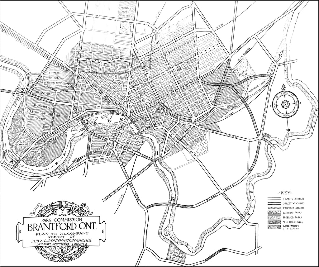

City of Brantford map with proposed circumferential streets and river crossings. Note: in West Brant Grant St is now Catharine St, Columbia Avenue does not exist but would lie between Graham and Clench Avenues. Oxford St and Burford St are now Colborne St West. On the east side of the city, Park St is now Park Rd N. The GT Ry (Grand Truck Railway) became Canadian National Railways (CNR). The B & H Elec Ry travelling over Mohawk Park on the east side of the city was the Brantford & Hamilton Electric Railway.
Murray and Clarence St for north/south traffic connecting with Cayuga St crossing the river at Strathcona St,
continuing across Catherine St to the river and crossing the river again to St Paul Ave and
along Burwell St west, again crossing the river.
Grand River Ave in Holmedale would continue across the Grand River meeting up with Oakhill Dr in West Brant.
Burkett Lane would cross the river connecting with Mount Pleasant St.
Today, Brantford has three river crossing, the Lorne Bridge, Veterans Memorial Parkway, and the Cockshutt Bridge. The Lorne Bridge and Veterans Memorial Parkway crossing are relatively close to each other whereas Dunington-Grubb’s plan would have provided six evenly spaced river crossings throughout the city.
Streets of various widths depending on their purpose, e.g. main artery, circumferential road, side streets, were advocated for rather than a standard city by-law fixing street widths regardless of purpose. This would ensure main thoroughfares were sufficiently wide in order to accommodate increased traffic as the city grew without the need for expensive expropriations when the need arose. Setback of houses from the street would also provide an opportunity to widen a street if the street started to convert to commercial use.
A surprising aspect of the report was that the development of a parks system was of secondary importance to the Dunington-Grubb’s. They felt that cities must be developed first on the lines of economy and efficiency. If this is done successfully they felt the process of beautification would proceed naturally and logically. Parks were subdivided into six categories: 1) City Squares - formal, surrounded by buildings of character, 2) Suburban Squares - developed chiefly with trees, shrubs, flowers, and grass, 3) City Parks - quiet spaces throughout the city, an escape from the bustling streets, 4) Parkways - thin strips that connect parks and provide separation of built elements from the streets, 5) Park Reservations - large tracts of natural woodlands on the perimeter of the city, and 6) Playgrounds - scattered throughout the city and within easy walking distance of every home.
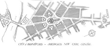
The report recognised the need for a strong traffic connection between the train station and West Brant, via West St, Bridge St, and the Lorne Bridge. This thoroughfare would pass by the Bell Memorial around which a Civic Square could be built where the City Hall and other important civic buildings would cluster. In addition, the report recommended a railway underpass on West St at the train station. This was finally built in 1930.

The report recommended the development of a park on the West Brant side of the Lorne Bridge. This eventually became Lorne Park and Fordview Park. Alexandra Park and Agricultural Park (now Cockshutt Park) were recommended for redevelopment to better suit the needs of park users. Waterworks Park was proposed which included areas for a trotting track and ball fields and canal side and riverside drives. A park at the site of the Bell Homestead was proposed complete with a covered terrace overlooking the river and paths and stairs leading to the river bank below. The acquisition of Mohawk Park, which was privately owned, was encouraged, to provide residents in the east end of Brantford with a large park for recreation and relaxation. Land in the north end was to be secured as the city was rapidly expanding north. City View Park and the playground below on Usher St were recommended as was a park to be situated in the valley of what is now Galileo Blvd. This site was not used for a park, rather Burnley Park was created.
Another key part to the proposal was the creation of parkways along the river, canal, and the crest of the hills surrounding Brantford. Their reasoning was that …the banks of rivers under private control are of little value, while, when developed and drawn together by the city into one unified scheme, the surrounding property frequently reaches a market value almost as high as any property in the city. Chicago and Saskatoon were cited as examples of cities reclaiming their water fronts. This ultimately never came to fruition in Brantford.
Dikes along the river banks were recommended because of annual flooding, however no serious effort began on this front until the 1980s.
Although Brantford had a good tree canopy, the report recommended that the Parks Commission manage street tree planting and tree selection for uniformity and spacing. It was felt streets had too many varieties of species often spaced too closely together. Chatham Street was singled out for having one of the finest avenues of American Elm trees on the continent. Recommended for street trees were the American Elm, Norway Maple, Red Oak, Pin Oak, the Oriental Plane, and the Chinese Tree of Heaven. The latter two trees were to be used in areas heavy with smoke and gases.
The Farmers’ Market was seen as an essential element for the continuing commercial success of the city. The downtown businesses benefit from their proximity to the market rather than the other way around. The report maintained that moving the market to a less prominent location in the city would likely have dire consequences for both the market and downtown. This appears to have rung true as the decline of the downtown as a commercial centre coincided with the moving of the market to its present site on Icomm Drive.
The report had this to say about the value of the former Market Square: open squares of this sort in the centre of a town are so rare an occurrence and of such priceless benefit to the city, especially when it grows large, that the destruction of the square would constitute nothing short of civil calamity. The removal of the Farmers’ Market, and the parking on Market Square, replaced by the Eaton Market Square mall, seems to have born out the authors worst fears.
With regards to housing, the report noted that the development of slums could be avoided through planning and innovation. Deep lots should not be allowed in order to prevent rear tenements and inner courts from being built behind the houses. The creation of a housing service organisation was suggested to help finance the construction of workers’ homes so they could be rented at an affordable rate yet provide a return to the investor.
Brantford would look much different today if the proposed road patterns, river crossings, and river and canal parkways were built. Would the downtown have remained vibrant if the Farmers’ Market was not moved? However some ideas from this report have been incorporated into the city plan as Brantford has evolved and grown, especially with respect to the parks system.